
I took the train to Portland, OR to meet my travel companions - the "Galoots." Here is Flo, my sleeping car attendant.

The traditional dining car, a disappearing feature, is one of the great attractions of train travel.

We left Saint Paul at night and I woke up in North Dakota. A typical Dakota scene: the ranch house is abandoned but there is an oil pump in the background.

The "rolling hills" of eastern Montana from the rear door of the train.
.")
The mountains suddenly appear in western Montana, near Glacier National Park (which has a stop and old railroad hotel).

Speeding along the Columbia River, we get a great view of Mount Hood.

After joining the Galoots, we visit Lava Beds Nationl Monument. Round lava-tube caves were formed when the hot center of a lava flow drained out, leaving the surrounding, cooler casing.
, Gary (St. Paul), me, Bob (Port Angeles, WA). All lived or live in the Twin Cities and three are runners.")
The Galoots: Bruce (Salem, OR), Gary (St. Paul), me, Bob (Port Angeles, WA). All lived or live in the Twin Cities and three are runners.

Lake Tahoe is beautiful and surprisingly unspoiled.

We hiked an uncrowded lakeside trail.

Amazingly, the next day we were in the hottest and lowest place in North America! This is Death Valley.

The lowest point in North America is a surreal landscape of vast salt flats.

Zabriskie Point dramatically shows old lava over eroded sedimentary rocks. It was named for the vice president of a borax company and is the title of a 1970 coming-of-age film.

We moved on to the White Pockets area, outside Kanab, Utah. This cave was used by Pueblo culture people, and there are still artifacts there.

Petroglyphs at the mouth of the cave depict antelope and/or big horn sheep.

We found blooming cactus in the vicinity, such as this beautiful "claret cup" cactus.

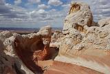
We hired a guide and 4-wheel drive vehicle to reach White Pockets. It consists of contorted bleached-white sandstone over red sandstone. It is beautiful and other-worldly at the same time.

White Pockets is deep within Vermillion Cliffs National Monument near the Arizona/Utah border and is notoriously hard to reach.

I stop for desert flowers.

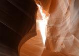
Antelope Canyon is a slot canyon on Navajo land near Page, Arizona. The Navaho name means 'the place where water runs through rocks.'

We visited Lower Antelope two years ago and were eager to hike Upper Antelope.

The sun peeks in from the top and illuminates the pink and orange sandstone.

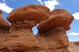
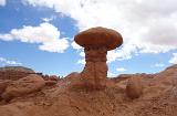
Goblin Valley State Park, UT, refers to the local name for hoodoos. These odd pillars occur when harder rock protects the soft, eroded material underneath.

This is the eeriest landscape we experienced, though that is a common trait in the Southwest.

Arches National Park offers monumental views, including the iconic Delicate Arch, Utah's state symbol.

The three mile round trip hike up to the arch offers great views, enabling us to see the impending rain.

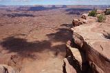
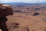
Needles Overlook is little-known but offers a spectacular view of Canyonlands National Park. The Colorado River is in the distance.

Back to Navaho lands. They and the Puebloan Indians still occupy Canyon de Chelly, in cooperation with the National Park Service.

The Canyon is a peaceful oasis surrounded by desert. This prickly pear grows on the rim. Only native Americans and those with guides are allowed in the Canyon.
.")
Our guide is part Navaho and part Zuni (of Pueblo culture).

We were surprised when our guide casually drove into the river. He pointed out the nearby quicksand.

The White House ruin was modified by Navahos, who arrived in the 1700's, but most of it is Puebloan. Our guide said the "upper" portion was once level with the land, as the bottom portion is now.

Pictographs near White House show animals and the jagged symbol of flooding.

Roadside scenery in northern Arizona.

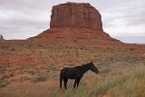
The Navaho nation voted to make Monument Valley a park in 1958 when commercial interests were moving in. Thankfully, it is well preserved.